


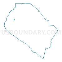
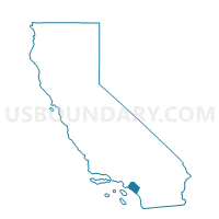
Voting District 11831, Orange County, California
About
Outline

Summary
| Unique Area Identifier | 536173 |
| Name | Voting District 11831 |
| County | Orange County |
| State | California |
| Area (square miles) | 0.31 |
| Land Area (square miles) | 0.31 |
| Water Area (square miles) | 0.00 |
| % of Land Area | 100.00 |
| % of Water Area | 0.00 |
| Latitude of the Internal Point | 33.76772430 |
| Longtitude of the Internal Point | -117.99462120 |
Maps

Graphs
Select a template below for downloading or customizing gragh for Voting District 11831, Orange County, California


Neighbors
Neighoring Voting District (by Name) Neighboring Voting District on the Map
- Voting District 11541, Orange County, CA
- Voting District 11556, Orange County, CA
- Voting District 11571, Orange County, CA
- Voting District 11586, Orange County, CA
- Voting District 11806, Orange County, CA
- Voting District 11821, Orange County, CA
- Voting District 11836, Orange County, CA
- Voting District 11841, Orange County, CA
- Voting District 11846, Orange County, CA
- Voting District 11871, Orange County, CA
- Voting District 11882, Orange County, CA
- Voting District 12452, Orange County, CA
Top 10 Neighboring County Subdivision (by Population) Neighboring County Subdivision on the Map
- Anaheim-Santa Ana-Garden Grove CCD, Orange County, CA (1,648,519)
- North Coast CCD, Orange County, CA (366,151)
Top 10 Neighboring Place (by Population) Neighboring Place on the Map
Top 10 Neighboring Elementary School District (by Population) Neighboring Elementary School District on the Map
Top 10 Neighboring Secondary School District (by Population) Neighboring Secondary School District on the Map
Top 10 Neighboring Unified School District (by Population) Neighboring Unified School District on the Map
Top 10 Neighboring State Legislative District Lower Chamber (by Population) Neighboring State Legislative District Lower Chamber on the Map
Top 10 Neighboring State Legislative District Upper Chamber (by Population) Neighboring State Legislative District Upper Chamber on the Map
Top 10 Neighboring 111th Congressional District (by Population) Neighboring 111th Congressional District on the Map
- Congressional District 40, CA (665,653)
- Congressional District 46, CA (648,663)
- Congressional District 47, CA (631,422)
Top 10 Neighboring Census Tract (by Population) Neighboring Census Tract on the Map
- Census Tract 888.01, Orange County, CA (8,343)
- Census Tract 999.04, Orange County, CA (6,352)
- Census Tract 998.01, Orange County, CA (5,816)
- Census Tract 888.02, Orange County, CA (5,551)
- Census Tract 998.02, Orange County, CA (5,111)
- Census Tract 881.06, Orange County, CA (4,638)